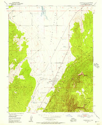
1950 Map of Kanarraville
USGS Topo · Published 1957About this map
Kanarraville serves as the focal point of this 1950s survey, situated where the floor of the Cedar Valley meets the dramatic ascent of the Hurricane Cliffs. The map illustrates a landscape of stark contrasts, with the agricultural and residential grid of the town positioned directly below the steep escarpments and canyons of what was then known as Zion National Monument. To the west, the Harmony Mountains rise across the valley, while the seasonal waters of Quichapa Lake dominate the northern terrain. Local landmarks such as the Cemetery and the Levee near the town center provide specific points of interest for genealogists and local historians. The mapping of the Rock Trail and numerous water sources like Mud Springs and Kanarra Creek highlights the essential relationship between the community and the surrounding high-desert environment during this era.
Find a feature on this map
26 named features on this map. Tap any name to fly to it.
Don’t see what you’re looking for? This feature index may not catch every label — zoom into the map to look around manually.
Map Details
Editions of this 1950 Kanarraville Map
5 editions found
Other maps of this area

1885 · St. George
USGS Topo · 1:250,000

1891 · St. George
USGS Topo · 1:250,000

1949 · Cedar City NW
USGS Topo · 1:24,000

1950 · Cedar City NW
USGS Topo · 1:24,000

1950 · Kanarraville
USGS Topo · 1:24,000

1950 · Cedar City
USGS Topo · 1:24,000

1950 · Iron Mountain
USGS Topo · 1:62,500

1950 · Cedar City
USGS Topo · 1:62,500

1950 · Cedar Mountain
USGS Topo · 1:24,000

1950 · Stoddard Mtn
USGS Topo · 1:24,000