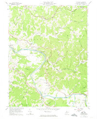
1957 Map of Kanawha
USGS Topo · Published 1974About this map
Little Kanawha River meanders through the heart of this mid-century landscape, joined by the Hughes River near the Wood and Wirt County line. The settlement pattern is defined by the Baltimore and Ohio railroad corridor, which links communities like Davisville, Kanawha Station, and Walker. This era represents a period of active resource extraction, as evidenced by the numerous Oil Wells scattered across the northern ridges such as Dutch Ridge.
Find a feature on this map
70 named features on this map. Tap any name to fly to it.
Don’t see what you’re looking for? This feature index may not catch every label — zoom into the map to look around manually.
Map Details
Editions of this 1957 Kanawha Map
4 editions found
Other maps of this area

1902 · Parkersburg
USGS Topo · 1:62,500

1904 · Parkersburg
USGS Topo · 1:62,500

1904 · Marietta
USGS Topo · 1:62,500

1906 · Elizabeth
USGS Topo · 1:62,500

1906 · Belleville
USGS Topo · 1:62,500

1924 · Belleville
USGS Topo · 1:62,500

1924 · Marietta
USGS Topo · 1:62,500

1924 · Elizabeth
USGS Topo · 1:62,500

1926 · Elizabeth
USGS Topo · 1:62,500

1926 · Belleville
USGS Topo · 1:62,500