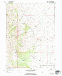
1968 Map of Kane Canyon
USGS Topo · Published 1972About this map
The Jim Sage Mountains dominate the western half of this Idaho survey, characterized by a series of high peaks and drainage systems that descend into the Raft River Valley to the east. Water is a defining element of this high-desert environment, evidenced by the numerous named water sources such as Red Rock Spring, Kane Spring, and the various springs that feed into Cottonwood Creek. The presence of a Prospect on the eastern flank of Red Rock Mountain points to early mineral exploration in the range, while the landscape is further defined by prominent landforms like Sheep Mountain and Cedar Knoll. A network of primitive transport routes, marked as jeep trails, follows the natural contours of the land, providing access through Kane Canyon and across the rugged slopes of the mountains.
Find a feature on this map
15 named features on this map. Tap any name to fly to it.
Don’t see what you’re looking for? This feature index may not catch every label — zoom into the map to look around manually.
Map Details
Editions of this 1968 Kane Canyon Map
2 editions found
Other maps of this area

1954 · Pocatello
USGS Topo · 1:250,000

1958 · Pocatello
USGS Topo · 1:250,000

1968 · Malta
USGS Topo · 1:24,000

1968 · Jim Sage Canyon
USGS Topo · 1:24,000

1968 · Elba
USGS Topo · 1:24,000

1968 · Kane Canyon
USGS Topo · 1:24,000

1968 · Nibbs Creek
USGS Topo · 1:24,000

1968 · Naf
USGS Topo · 1:24,000

1968 · Chokecherry Canyon
USGS Topo · 1:24,000
1968 · Connor Ridge
USGS Topo · 1:24,000