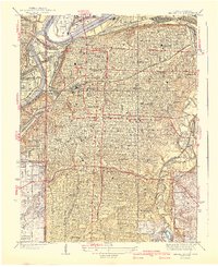
1940 Map of Kansas City
USGS Topo · Published 1940About this map
The Missouri River and Kansas River confluence defines this urban landscape at the onset of the 1940s, revealing the dense rail infrastructure and civic expansion of the era. The massive rail network of the Kansas City Terminal and Kansas City Southern converges at the iconic Union Station, which served as the city's pulsing logistical heart. To the north, the Kansas City Airport sits in the river bend across from Harlem, while the southern residential reaches are anchored by institutions like the University of Kansas City and Rockhurst College. The mapping of extensive parklands, from the winding paths of Swope Park to the prominent Loose Memorial Park, illustrates the city's commitment to the City Beautiful movement. Cultural and social history is visible in the numerous medical and educational landmarks, including Wheatley Hospital and the sprawling Central High Schools complex.
Find a feature on this map
109 named features on this map. Tap any name to fly to it.
Don’t see what you’re looking for? This feature index may not catch every label — zoom into the map to look around manually.
Map Details
Editions of this 1940 Kansas City Map
3 editions found
Other maps of this area

1887 · Harrisonville
USGS Topo · 1:125,000

1887 · Olathe
USGS Topo · 1:125,000

1890 · Kansas City
USGS Topo · 1:125,000

1892 · Harrisonville
USGS Topo · 1:125,000

1893 · Olathe
USGS Topo · 1:125,000

1894 · Kansas City
USGS Topo · 1:125,000

1894 · Harrisonville
USGS Topo · 1:125,000

1894 · Independence
USGS Topo · 1:125,000

1934 · Independence
USGS Topo · 1:24,000

1934 · Grandview
USGS Topo · 1:24,000