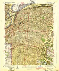
1940 Map of Kansas City
USGS Topo · Published 1940About this map
The dense grid of Kansas City is defined by its strategic position at the confluence of the Missouri River and the Kansas River in this late-1930s survey. The map details a city shaped by its logistics, showing the extensive rail networks of the Kansas City Terminal and Missouri Pacific lines that feed into the massive Union Station and the sprawling Stock Yards district. Significant civic investments of the era are visible, including the Kansas City Airport on the bend of the Missouri and the prominent Liberty Memorial. Educational and religious institutions such as Rockhurst College, University of Kansas City, and St Vincents Hospital are established across the landscape. The city's eastern and southern expansion is marked by large green spaces like Swope Park and numerous historic burial grounds, including Elmwood Cem and Union Cem, providing a detailed look at the metropolitan core before the post-war highway boom.
Find a feature on this map
94 named features on this map. Tap any name to fly to it.
Don’t see what you’re looking for? This feature index may not catch every label — zoom into the map to look around manually.
Map Details
Editions of this 1940 Kansas City Map
3 editions found
Other maps of this area

1887 · Harrisonville
USGS Topo · 1:125,000

1887 · Olathe
USGS Topo · 1:125,000

1890 · Kansas City
USGS Topo · 1:125,000

1892 · Harrisonville
USGS Topo · 1:125,000

1893 · Olathe
USGS Topo · 1:125,000

1894 · Kansas City
USGS Topo · 1:125,000

1894 · Harrisonville
USGS Topo · 1:125,000

1894 · Independence
USGS Topo · 1:125,000

1934 · Independence
USGS Topo · 1:24,000

1934 · Grandview
USGS Topo · 1:24,000