
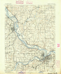
1890 Map of Kansas City
USGS Topo · Published 1890About this map
Kansas City and the surrounding river bluffs are shown here during a period of massive railroad expansion in the late 1880s. The Missouri River anchors the geography, winding past numerous islands such as Kickapoo Island and Spar Island while separating the major centers of Leavenworth and Platte City. This survey, compiled from work by the Engineer Corps U.S. Army and the U.S. Geological Survey, captures the region before modern flood controls altered the river's path, notably around the Old Channel of Platte River.
Find a feature on this map
137 named features on this map. Tap any name to fly to it.
Don’t see what you’re looking for? This feature index may not catch every label — zoom into the map to look around manually.
Map Details
Editions of this 1890 Kansas City Map
2 editions found
Other maps of this area

1885 · Atchison
USGS Topo · 1:125,000

1885 · Lawrence
USGS Topo · 1:125,000

1886 · Oskaloosa
USGS Topo · 1:125,000

1887 · Harrisonville
USGS Topo · 1:125,000

1887 · Olathe
USGS Topo · 1:125,000

1888 · Oskaloosa
USGS Topo · 1:125,000

1888 · Atchison
USGS Topo · 1:125,000

1889 · Lawrence
USGS Topo · 1:125,000

1892 · Harrisonville
USGS Topo · 1:125,000

1893 · Atchison
USGS Topo · 1:125,000