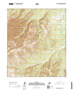
2017 Map of Kantishna River B-4 NW
USGS Topo · Published 2017About this map
The Bitzshtini Mountains dominate the western portion of this Alaskan interior landscape, where steep ridgelines give way to the winding course of the Cosna River. Flowing across the southern and eastern reaches, the river establishes a sharp contrast between the high terrain and the lower drainage basins characteristic of the Yukon-Koyukuk region. This 2017 survey reflects the remote, roadless character of the territory, defined by the Public Land Survey System grids of t5s r22w, t5s r21w, t6s r22w, and t6s r21w. The topography reveals the complex drainage patterns of a subarctic environment, where the elevation drops from the summits of the Bitzshtini Mountains toward the alluvial valleys of the Cosna River, providing a clear look at the geological transitions within this unpopulated wilderness.
Find a feature on this map
6 named features on this map. Tap any name to fly to it.
Don’t see what you’re looking for? This feature index may not catch every label — zoom into the map to look around manually.
Map Details
Editions of this 2017 Kantishna River B-4 NW Map
This is the sole edition of this map. No revisions or reprints were ever made.
Other maps of this area

1948 · Kantishna River
USGS Topo · 1:250,000

1951 · Kantishna River
USGS Topo · 1:250,000

1952 · Kantishna River C-5
USGS Topo · 1:63,360

1952 · Kantishna River
USGS Topo · 1:250,000

1952 · Kantishna River B-5
USGS Topo · 1:63,360

1952 · Kantishna River C-4
USGS Topo · 1:63,360

1953 · Kantishna River B-4
USGS Topo · 1:63,360
1955 · Kantishna River C-4
USGS Topo · 1:63,360

1964 · Kantishna River
USGS Topo · 1:250,000
2017 · Kantishna River B-4 SE
USGS Topo · 1:25,000