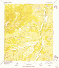
1955 Map of Kantishna River C-4
USGS Topo · Published 1956About this map
The Cosna River serpentines through the eastern portion of this mid-century topographic study, defining the drainage patterns of this interior Alaska wilderness. Compiled from 1952 aerial photography and 1955 photogrammetric methods, the map focuses on the complex elevations of the Yukon-Koyukuk region before the development of modern infrastructure. The landscape is dominated by high points used for geodetic surveying, specifically VABM Tan 2486 in the northwest and VABM Zitz 1441 in the southeast. These vertical angle bench marks served as critical reference points for the U.S. Geological Survey during the systematic mapping of the Alaska-Fourth Judicial Division. The contour intervals illustrate a highly varied topography of ridges and low-lying wetlands, typical of the interior river systems during the post-war era of Alaskan territorial mapping.
Find a feature on this map
3 named features on this map. Tap any name to fly to it.
Don’t see what you’re looking for? This feature index may not catch every label — zoom into the map to look around manually.
Map Details
Editions of this 1955 Kantishna River C-4 Map
This is the sole edition of this map. No revisions or reprints were ever made.
Other maps of this area

1948 · Kantishna River
USGS Topo · 1:250,000

1951 · Kantishna River
USGS Topo · 1:250,000

1952 · Kantishna River C-5
USGS Topo · 1:63,360

1952 · Kantishna River D-5
USGS Topo · 1:63,360

1952 · Kantishna River
USGS Topo · 1:250,000

1952 · Kantishna River B-5
USGS Topo · 1:63,360

1952 · Kantishna River D-3
USGS Topo · 1:63,360

1952 · Kantishna River C-3
USGS Topo · 1:63,360

1952 · Kantishna River C-4
USGS Topo · 1:63,360

1953 · Kantishna River B-4
USGS Topo · 1:63,360