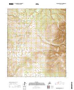
2017 Map of Kantishna River B-5 NE
USGS Topo · Published 2017About this map
The eastern reaches of the Bitzshtini Mountains dominate this interior Alaska landscape, where steep ridgelines contrast with the lower, wetland-rich basins to the west. This 2017 U.S. Geological Survey topographic study documents the Public Land Survey System grid across portions of Townships 5 and 6 South, Ranges 22, 23, and 24 West. The terrain transitions from the high peaks of the Bitzshtini Mountains in the northeast corner down to an intricate network of unnamed ponds and drainage basins. This area reflects the remote character of the Yukon-Koyukuk region, where the absence of roads or established settlements emphasizes the natural topography of the Alaska interior. The map provides a detailed view of the contour intervals and hydrographic patterns essential for understanding the physical geography of this subarctic wilderness.
Find a feature on this map
7 named features on this map. Tap any name to fly to it.
Don’t see what you’re looking for? This feature index may not catch every label — zoom into the map to look around manually.
Map Details
Editions of this 2017 Kantishna River B-5 NE Map
This is the sole edition of this map. No revisions or reprints were ever made.
Other maps of this area

1948 · Kantishna River
USGS Topo · 1:250,000

1951 · Kantishna River
USGS Topo · 1:250,000

1952 · Kantishna River C-5
USGS Topo · 1:63,360

1952 · Kantishna River
USGS Topo · 1:250,000

1952 · Kantishna River B-5
USGS Topo · 1:63,360

1952 · Kantishna River C-4
USGS Topo · 1:63,360

1953 · Kantishna River B-4
USGS Topo · 1:63,360
1955 · Kantishna River C-4
USGS Topo · 1:63,360

1964 · Kantishna River
USGS Topo · 1:250,000
2017 · Kantishna River C-5 SW
USGS Topo · 1:25,000