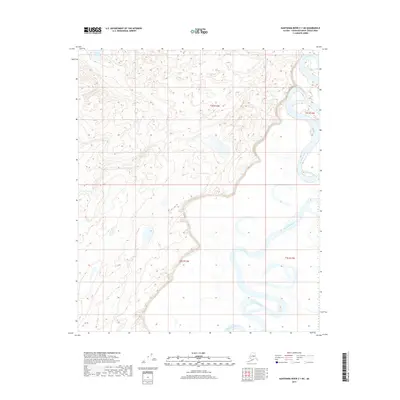
2017 Map of Kantishna River C-1 NE
USGS Topo · Published 2017About this map
Kantishna River meanders across this interior landscape within the Yukon-Koyukuk Census Area, defining a terrain shaped by dynamic hydrologic patterns. The river’s path is marked by dramatic oxbow bends and abandoned channels, illustrating the shifting nature of the drainage basin in the Unorganized Borough. Near the northwestern corner of the sheet, Iksgiza Lake sits as a prominent water feature amidst the complex network of wetlands and smaller ponds. Surveyed in the 21st century by the U.S. Geological Survey, this topographical study documents the intricate boundary lines between townships t2s r13w, t2s r12w, t3s r13w, and t3s r12w, providing a precise record of the public land survey system in this part of Alaska.
Find a feature on this map
6 named features on this map. Tap any name to fly to it.
Don’t see what you’re looking for? This feature index may not catch every label — zoom into the map to look around manually.
Map Details
Editions of this 2017 Kantishna River C-1 NE Map
This is the sole edition of this map. No revisions or reprints were ever made.
Other maps of this area

1948 · Kantishna River
USGS Topo · 1:250,000

1950 · Fairbanks
USGS Topo · 1:250,000

1951 · Kantishna River
USGS Topo · 1:250,000

1951 · Fairbanks
USGS Topo · 1:250,000

1952 · Kantishna River C-1
USGS Topo · 1:63,360

1952 · Kantishna River
USGS Topo · 1:250,000

1952 · Fairbanks
USGS Topo · 1:250,000
1952 · Fairbanks D-6
USGS Topo · 1:63,360
1953 · Fairbanks C-6
USGS Topo · 1:63,360
1953 · Kantishna River D-1
USGS Topo · 1:63,360