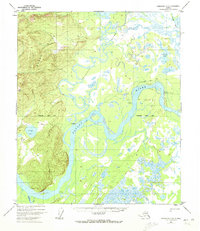
1952 Map of Fairbanks D-6
USGS Topo · Published 1972About this map
The confluence of the Tolovana River and the Tanana River anchors this interior landscape, which was documented by photogrammetric methods in the early 1950s. The settlement of Tolovana sits along the northern bank of the Tanana, positioned near where the river system begins its winding course through extensive wetlands and sloughs. To the west, the Dugan Hills provide a significant change in elevation, contrasting with the low-lying basin of Deadman Lake.
Find a feature on this map
13 named features on this map. Tap any name to fly to it.
Don’t see what you’re looking for? This feature index may not catch every label — zoom into the map to look around manually.
Map Details
Editions of this 1952 Fairbanks D-6 Map
2 editions found
Other maps of this area

1945 · Livengood
USGS Topo · 1:250,000

1948 · Kantishna River
USGS Topo · 1:250,000

1950 · Fairbanks
USGS Topo · 1:250,000

1950 · Fairbanks C-5
USGS Topo · 1:63,360

1950 · Fairbanks D-5
USGS Topo · 1:63,360

1951 · Kantishna River
USGS Topo · 1:250,000

1951 · Fairbanks
USGS Topo · 1:250,000

1951 · Tanana
USGS Topo · 1:250,000

1951 · Livengood
USGS Topo · 1:250,000

1951 · Livengood A-5
USGS Topo · 1:63,360