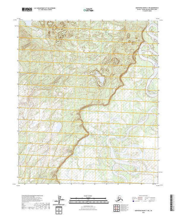
2024 Map of Kantishna River C-1 NE
USGS Topo · Published 2024About this map
Kantishna River meanders through this interior Alaska landscape, defining the primary topographic and hydrologic character of the region. The river's winding course creates a complex network of oxbow lakes and wetlands, indicative of a low-lying, shifting floodplain within the T3s R12w and T2s R12w townships. This 2024 survey reflects the modern wilderness state of the Yukon-Koyukuk Census Area, where human infrastructure is absent, leaving the braided hydrology and elevation contours to tell the story of the land. The mapping provided by the U.S. Geological Survey emphasizes the natural drainage patterns and the subtle rise of terrain away from the river banks, providing a foundational record for ecological study or remote navigation in this part of the Alaskan bush.
Find a feature on this map
5 named features on this map. Tap any name to fly to it.
Don’t see what you’re looking for? This feature index may not catch every label — zoom into the map to look around manually.
Map Details
Editions of this 2024 Kantishna River C-1 NE Map
This is the sole edition of this map. No revisions or reprints were ever made.
Other maps of this area

1948 · Kantishna River
USGS Topo · 1:250,000

1950 · Fairbanks
USGS Topo · 1:250,000

1951 · Kantishna River
USGS Topo · 1:250,000

1951 · Fairbanks
USGS Topo · 1:250,000

1952 · Kantishna River C-1
USGS Topo · 1:63,360

1952 · Kantishna River
USGS Topo · 1:250,000

1952 · Fairbanks
USGS Topo · 1:250,000
1952 · Fairbanks D-6
USGS Topo · 1:63,360
1953 · Fairbanks C-6
USGS Topo · 1:63,360
1953 · Kantishna River D-1
USGS Topo · 1:63,360