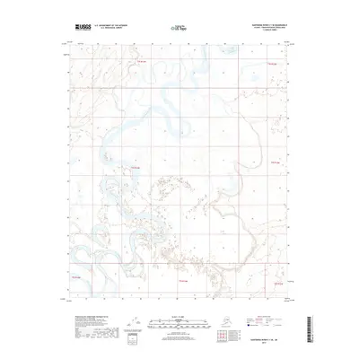
2017 Map of Kantishna River C-1 SE
USGS Topo · Published 2017About this map
Kantishna River dominates this interior Alaska landscape, winding through a complex network of oxbow lakes and abandoned channels that characterize the region's low-lying drainage patterns. This 2017 survey shows the river's highly serpentine path as it moves across the t4s r13w and t5s r13w townships within the Yukon-Koyukuk Census Area. The lack of infrastructure or named settlements highlights the natural isolation of this territory, where the only other distinct waterway noted is the tributary Dry Cr. The map's contour lines and wetland indicators provide a fine-grained view of the subtle elevation changes that dictate the shifting course of the river over time.
Find a feature on this map
9 named features on this map. Tap any name to fly to it.
Don’t see what you’re looking for? This feature index may not catch every label — zoom into the map to look around manually.
Map Details
Editions of this 2017 Kantishna River C-1 SE Map
This is the sole edition of this map. No revisions or reprints were ever made.
Other maps of this area

1948 · Kantishna River
USGS Topo · 1:250,000

1950 · Fairbanks
USGS Topo · 1:250,000

1951 · Kantishna River
USGS Topo · 1:250,000

1951 · Fairbanks
USGS Topo · 1:250,000

1952 · Kantishna River C-1
USGS Topo · 1:63,360

1952 · Kantishna River
USGS Topo · 1:250,000

1952 · Kantishna River B-1
USGS Topo · 1:63,360

1952 · Fairbanks
USGS Topo · 1:250,000
1953 · Fairbanks C-6
USGS Topo · 1:63,360
1953 · Fairbanks B-6
USGS Topo · 1:63,360