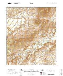
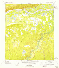
2017 Map of Kantishna River C-3 NE
USGS Topo · Published 2017About this map
The Zitziana River carves a winding path through this corner of the Yukon-Koyukuk region, defining a landscape shaped by vast interior drainage systems. Rising above the river plains, Mooseheart Mtn serves as a prominent landmark in the northeastern portion of the map, offering a distinct contrast to the surrounding low-lying terrain. This 2017 survey details the complex topography of the Alaska interior, where the river's numerous oxbows and meanders indicate an environment of shifting watercourses. The map is primarily organized by its public land survey system grid, encompassing portions of t2s r18w, t2s r17w, t3s r18w, and t3s r17w. This lack of named settlements emphasizes the character of the region as a preserved wilderness area, where natural features remain the primary points of orientation.
Find a feature on this map
6 named features on this map. Tap any name to fly to it.
Don’t see what you’re looking for? This feature index may not catch every label — zoom into the map to look around manually.
Map Details
Editions of this 2017 Kantishna River C-3 NE Map
This is the sole edition of this map. No revisions or reprints were ever made.
Other maps of this area

1948 · Kantishna River
USGS Topo · 1:250,000

1951 · Kantishna River
USGS Topo · 1:250,000

1952 · Kantishna River
USGS Topo · 1:250,000

1952 · Kantishna River D-2
USGS Topo · 1:63,360

1952 · Kantishna River D-3
USGS Topo · 1:63,360

1952 · Kantishna River C-3
USGS Topo · 1:63,360
1953 · Kantishna River C-2
USGS Topo · 1:63,360
1954 · Kantishna River D-3
USGS Topo · 1:63,360
1954 · Kantishna River C-2
USGS Topo · 1:63,360
1954 · Kantishna River D-2
USGS Topo · 1:63,360