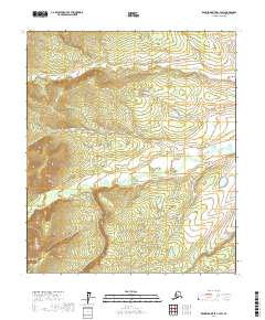
2017 Map of Kantishna River C-4 SW
USGS Topo · Published 2017About this map
The interior of Alaska's Yukon-Koyukuk region is defined by its topographic complexity and lack of formal human infrastructure in this 2017 survey. The landscape is organized via the Public Land Survey System, spanning across T3s R22w, T3s R21w, and T4s R22w. These township and range designations serve as the primary identifiers for this wilderness area, where contour lines reveal a network of high ridges and deep drainage basins that characterize the Kantishna River watershed. The map details the elevation changes across T4s R21w, T5s R22w, and T5s R21w, providing an essential record for land management and remote navigation in a region without established roads or settlements.
Find a feature on this map
6 named features on this map. Tap any name to fly to it.
Don’t see what you’re looking for? This feature index may not catch every label — zoom into the map to look around manually.
Map Details
Editions of this 2017 Kantishna River C-4 SW Map
This is the sole edition of this map. No revisions or reprints were ever made.
Other maps of this area

1948 · Kantishna River
USGS Topo · 1:250,000

1951 · Kantishna River
USGS Topo · 1:250,000

1952 · Kantishna River C-5
USGS Topo · 1:63,360

1952 · Kantishna River
USGS Topo · 1:250,000

1952 · Kantishna River B-5
USGS Topo · 1:63,360

1952 · Kantishna River C-4
USGS Topo · 1:63,360

1953 · Kantishna River B-4
USGS Topo · 1:63,360
1955 · Kantishna River C-4
USGS Topo · 1:63,360

1964 · Kantishna River
USGS Topo · 1:250,000
2017 · Kantishna River C-4 NE
USGS Topo · 1:25,000