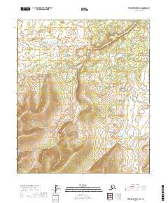
2017 Map of Kantishna River C-6 SE
USGS Topo · Published 2017About this map
Chitanana River defines the southeastern corner of this Alaskan interior landscape, winding through a complex network of wetlands and low-lying drainages. The area is characterized by an intricate system of small ponds and unnamed water bodies that sit within the larger Tanana Valley drainage. While human settlements are absent from this specific quadrangle, the terrain is meticulously partitioned by the Public Land Survey System, including sections within t3s r26w, t3s r25w, and t5s r25w. The topography transitions from these water-logged lowlands to higher elevations in the south and west, where the contour lines tighten to reveal significant rises above the river basin.
Find a feature on this map
7 named features on this map. Tap any name to fly to it.
Don’t see what you’re looking for? This feature index may not catch every label — zoom into the map to look around manually.
Map Details
Editions of this 2017 Kantishna River C-6 SE Map
This is the sole edition of this map. No revisions or reprints were ever made.
Other maps of this area

1948 · Kantishna River
USGS Topo · 1:250,000

1951 · Kantishna River
USGS Topo · 1:250,000

1952 · Kantishna River C-5
USGS Topo · 1:63,360

1952 · Kantishna River C-6
USGS Topo · 1:63,360

1952 · Kantishna River
USGS Topo · 1:250,000

1952 · Kantishna River B-6
USGS Topo · 1:63,360

1952 · Kantishna River B-5
USGS Topo · 1:63,360

1964 · Kantishna River
USGS Topo · 1:250,000
2017 · Kantishna River C-6 SW
USGS Topo · 1:25,000
2017 · Kantishna River B-6 NE
USGS Topo · 1:25,000