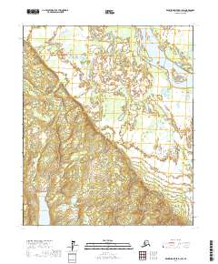
2017 Map of Kantishna River D-1 SW
USGS Topo · Published 2017About this map
The Tanana River sweeps across the northeastern corner of this interior Alaska landscape, defining a low-lying riparian corridor that contrasts with the rising terrain to the west. This 2017 survey reveals a largely roadless expanse within the Yukon-Koyukuk Census Area, where water bodies like Kindanina Lake and Iksgiza Lake suggest the complex drainage patterns characteristic of the Kantishna River region. The topography transitions from broad alluvial flats near the river to a more pronounced upland toward the southwestern corner, offering a clear view of the natural hydrology and land divisions including t1n r14w and t2s r15w. The absence of developed infrastructure underscores the wilderness character of the territory during this period.
Find a feature on this map
9 named features on this map. Tap any name to fly to it.
Don’t see what you’re looking for? This feature index may not catch every label — zoom into the map to look around manually.
Map Details
Editions of this 2017 Kantishna River D-1 SW Map
This is the sole edition of this map. No revisions or reprints were ever made.
Other maps of this area

1948 · Kantishna River
USGS Topo · 1:250,000

1951 · Kantishna River
USGS Topo · 1:250,000

1952 · Kantishna River C-1
USGS Topo · 1:63,360

1952 · Kantishna River
USGS Topo · 1:250,000

1952 · Kantishna River D-2
USGS Topo · 1:63,360
1953 · Kantishna River D-1
USGS Topo · 1:63,360
1953 · Kantishna River C-2
USGS Topo · 1:63,360
1954 · Kantishna River D-1
USGS Topo · 1:63,360
1954 · Kantishna River C-2
USGS Topo · 1:63,360
1954 · Kantishna River D-2
USGS Topo · 1:63,360