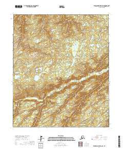
2017 Map of Kantishna River D-6 NE
USGS Topo · Published 2017About this map
Boney Cr and Beaver Cr meander through this subarctic interior landscape in the Yukon-Koyukuk Census Area. The terrain is defined by a dense network of small lakes and marshy lowlands, indicating a classic permafrost-affected drainage system typical of the Tanana Valley region. The map is organized by the Public Land Survey System, showing the junctions of t2n r26w, t2n r25w, and t2n r24w, which provide essential reference points for land claims and historical navigation in this uninhabited portion of the Alaska interior. The winding paths of the creeks suggest a slow-moving hydrological environment where seasonal changes significantly alter the accessible landscape.
Find a feature on this map
8 named features on this map. Tap any name to fly to it.
Don’t see what you’re looking for? This feature index may not catch every label — zoom into the map to look around manually.
Map Details
Editions of this 2017 Kantishna River D-6 NE Map
This is the sole edition of this map. No revisions or reprints were ever made.
Other maps of this area

1948 · Kantishna River
USGS Topo · 1:250,000

1951 · Kantishna River
USGS Topo · 1:250,000

1951 · Tanana
USGS Topo · 1:250,000

1952 · Kantishna River D-5
USGS Topo · 1:63,360

1952 · Kantishna River
USGS Topo · 1:250,000

1952 · Tanana A-6
USGS Topo · 1:63,360

1952 · Kantishna River D-6
USGS Topo · 1:63,360

1952 · Tanana A-5
USGS Topo · 1:63,360
1953 · Kantishna River D-5
USGS Topo · 1:63,360

1953 · Tanana A-5
USGS Topo · 1:63,360