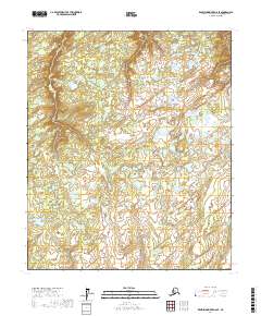
2017 Map of Kantishna River D-6 SE
USGS Topo · Published 2017About this map
Wetlands and complex water systems define this interior Alaskan landscape within the Yukon-Koyukuk Census Area. The terrain is characterized by a dense network of lakes, ponds, and unnamed watercourses, illustrating the hydrologic patterns common to the Tanana-Kuskowokwim Lowlands. This 2017 survey follows the Public Land Survey System divisions, documenting the geography of several townships including T1n R25w, T1s R25w, and T2s R25w. The lack of named settlements or roads underscore the area's isolation and its status as a largely roadless wilderness. Instead, the map provides a precise look at the fine-scale contours and drainage basins, crucial for understanding the shifting seasonal wetlands and the topography between the T1n R26w and T1n R24w boundaries.
Find a feature on this map
7 named features on this map. Tap any name to fly to it.
Don’t see what you’re looking for? This feature index may not catch every label — zoom into the map to look around manually.
Map Details
Editions of this 2017 Kantishna River D-6 SE Map
This is the sole edition of this map. No revisions or reprints were ever made.
Other maps of this area

1948 · Kantishna River
USGS Topo · 1:250,000

1951 · Kantishna River
USGS Topo · 1:250,000

1952 · Kantishna River C-5
USGS Topo · 1:63,360

1952 · Kantishna River C-6
USGS Topo · 1:63,360

1952 · Kantishna River D-5
USGS Topo · 1:63,360

1952 · Kantishna River
USGS Topo · 1:250,000

1952 · Kantishna River D-6
USGS Topo · 1:63,360
1953 · Kantishna River D-5
USGS Topo · 1:63,360

1964 · Kantishna River
USGS Topo · 1:250,000
2017 · Kantishna River D-6 SW
USGS Topo · 1:25,000