
1933 Map of Karankawa Lake
USGS Topo · Published 1933About this map
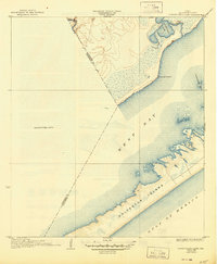
Galveston Island stretches across the lower portion of this coastal survey, separating the open Gulf of Mexico from the shallow reaches of West Bay. Surveyed in the late 1920s, the map highlights the intricate shoreline and marshy transition zones between land and sea. This edition was compiled in part from early aerial photographs taken by the Air Corps, showing the complex hydrology of Karankawa Lake and Karankawa Bayou near the northern shoreline. The boundary between Galveston and Brazoria counties is clearly delineated as it cuts through the bay waters toward the mainland. Coastal features like Karankawa Point and the submerged Karankawa Reef illustrate the natural hazards and geography of the bay as they appeared before extensive modern dredging or development. To the east, the enclosed waters of Lake Como sit behind the protective barrier of the island beach.
Find a feature on this map
14 named features on this map. Tap any name to fly to it.
Don’t see what you’re looking for? This feature index may not catch every label — zoom into the map to look around manually.
Map Details
Editions of this 1933 Karankawa Lake Map
2 editions found
Other maps of this area

1929 · Karankawa Lake
USGS Topo · 1:24,000

1929 · Hitchcock
USGS Topo · 1:24,000

1929 · Virginia Point
USGS Topo · 1:24,000

1931 · Lake Como
USGS Topo · 1:24,000

1932 · Hitchcock
USGS Topo · 1:31,680

1932 · Mustang Bayou
USGS Topo · 1:31,680

1932 · Virginia Point
USGS Topo · 1:31,680

1933 · San Luis Pass
USGS Topo · 1:31,680
1933 · Lake Como
USGS Topo · 1:31,680

1943 · San Luis Pass
USGS Topo · 1:31,680