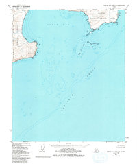
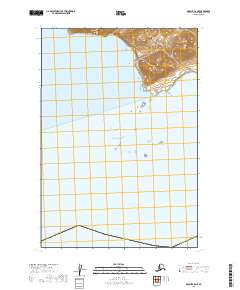
1951 Map of Karluk C-4 and C-5
USGS Topo · Published 1980About this map
The Becharof National Wildlife Refuge and the surrounding wilderness dominate this 1951 coastal survey, capturing a wild stretch of the Alaska Peninsula before the era of modern development. The landscape is defined by the massive reach of Shelikof Strait, which borders the intricate coastline of Puale Bay. This coastal environment is marked by prominent landmarks such as Cape Aklek and Cape Kekurnoi, serving as critical navigational points for the region’s maritime traffic. Inland, the map documents small drainages like Kati Creek and Teresa Creek, alongside a few isolated structures simply labeled Cabin. These scattered improvements and a single Trail indicate the minimal human footprint in what remains one of the most secluded parts of the maritime refuge system.
Find a feature on this map
17 named features on this map. Tap any name to fly to it.
Don’t see what you’re looking for? This feature index may not catch every label — zoom into the map to look around manually.
Map Details
Editions of this 1951 Karluk C-4 and C-5 Map
2 editions found
Other maps of this area

1951 · Karluk
USGS Topo · 1:250,000

1951 · Karluk D-6
USGS Topo · 1:63,360
1951 · Karluk C-4 and C-5
USGS Topo · 1:63,360

1951 · Karluk D-4
USGS Topo · 1:63,360

1951 · Karluk D-5
USGS Topo · 1:63,360
1951 · Karluk C-6
USGS Topo · 1:63,360

1952 · Karluk
USGS Topo · 1:250,000

1964 · Karluk
USGS Topo · 1:250,000
1971 · Karluk C-4 and C-5
USGS Topo · 1:63,360
2019 · Karluk C-5 NE
USGS Topo · 1:25,000