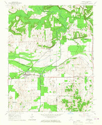
1966 Map of Karnak
USGS Topo · Published 1967About this map
The Cache River lowlands dominate this mid-1960s landscape, where complex drainage systems like the Post Creek Cutoff and Main Ditch reengineered the river's natural course. This intersection of three southern Illinois counties—Johnson, Pulaski, and Massac—reveals a hub of mid-century rail activity, with the Chicago and North Western, New York Central, and Chicago and Eastern Illinois railroads all converging near Karnak.
Find a feature on this map
43 named features on this map. Tap any name to fly to it.
Don’t see what you’re looking for? This feature index may not catch every label — zoom into the map to look around manually.
Map Details
Editions of this 1966 Karnak Map
3 editions found
Other maps of this area

1918 · Vienna
USGS Topo · 1:62,500

1919 · Vienna
USGS Topo · 1:62,500

1920 · Dongola
USGS Topo · 1:62,500

1923 · Dongola
USGS Topo · 1:62,500

1928 · La Center
USGS Topo · 1:62,500

1931 · Cairo
USGS Topo · 1:62,500

1932 · La Center
USGS Topo · 1:62,500

1933 · Cairo
USGS Topo · 1:62,500

1939 · Cairo
USGS Topo · 1:62,500

1942 · Vienna
USGS Topo · 1:62,500