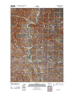
2011 Map of Kaskela
USGS Topo · Published 2011About this map
The Deschutes River carves a deep path through this portion of Wasco County, serving as the central axis for remote ranching and transit points. At North Junction, the landscape reflects the intersection of river geography and rural infrastructure, while the small settlement of Kaskela sits further south along the riverbank. The presence of Whiskey Dick Ranch and Hardy Ranch indicates the long-standing agricultural use of these canyon-adjacent lands. Water sources are critical in this arid environment, marked by numerous named features such as Jersey School Spring, Boiling Spring, and Larson Spring. The terrain is defined by distinctive landforms like The Pot and several deep coves, including Little Cove and Big Cove. This map provides a detailed view of the access roads like South Junction Rd and various service routes that navigate the complex drainage systems of Antoken Creek and Oak Creek.
Find a feature on this map
27 named features on this map. Tap any name to fly to it.
Don’t see what you’re looking for? This feature index may not catch every label — zoom into the map to look around manually.
Map Details
Editions of this 2011 Kaskela Map
This is the sole edition of this map. No revisions or reprints were ever made.
Other maps of this area
1928 · Madras
USGS Topo · 1:125,000
1930 · Dufur
USGS Topo · 1:125,000
1931 · Madras
USGS Topo · 1:125,000
1934 · Dufur
USGS Topo · 1:125,000
1953 · The Dalles
USGS Topo · 1:250,000
1955 · Bend
USGS Topo · 1:250,000
1956 · The Dalles
USGS Topo · 1:250,000
1957 · Bend
USGS Topo · 1:250,000
1957 · The Dalles
USGS Topo · 1:250,000
1958 · Bend
USGS Topo · 1:250,000