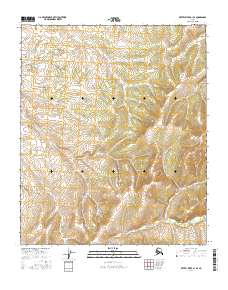
2016 Map of Kateel River A-1 SE
USGS Topo · Published 2016About this map
Duck Lake sits within a landscape defined by the intersection of several township boundaries in this 2016 survey of the interior. The terrain is characterized by complex contouring across t4s r13e, t4s r14e, and southern sections like t6s r14e. While largely devoid of named settlements or infrastructure, the map provides a precise layout of the Public Land Survey System (PLSS) grid, documenting the administrative divisions of this remote territory. The presence of Duck Lake on the western edge serves as the primary named hydrological feature, offering a specific point of reference for researchers and surveyors tracking environmental data or land tenure in the Yukon-Koyukuk region. This record was produced through a synthesis of SPOT imagery and elevation datasets, capturing the state of the land at the beginning of the 21st century.
Find a feature on this map
7 named features on this map. Tap any name to fly to it.
Don’t see what you’re looking for? This feature index may not catch every label — zoom into the map to look around manually.
Map Details
Editions of this 2016 Kateel River A-1 SE Map
This is the sole edition of this map. No revisions or reprints were ever made.
Other maps of this area

1945 · Nulato
USGS Topo · 1:250,000

1951 · Nulato
USGS Topo · 1:250,000

1951 · Ruby
USGS Topo · 1:250,000

1951 · Kateel River
USGS Topo · 1:250,000

1951 · Melozitna
USGS Topo · 1:250,000

1952 · Nulato D-1
USGS Topo · 1:63,360

1952 · Ruby D-6
USGS Topo · 1:63,360

1952 · Kateel River A-1
USGS Topo · 1:63,360

1952 · Nulato
USGS Topo · 1:250,000
1952 · Melozitna A-6
USGS Topo · 1:63,360