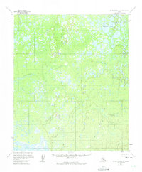
1952 Map of Kateel River A-2
USGS Topo · Published 1975About this map
Hozatka Lake sits in the northeast corner of this remote Interior landscape, part of a dense network of water bodies and wetlands across the central Yukon-Koyukuk region. Meandering through the central terrain, the Natlaratlen River defines the drainage pattern of this unsurveyed wilderness. The 1952 photogrammetric survey reveals a land defined almost entirely by its hydrology, with hundreds of unnamed thaw lakes and ponds scattered across the low-lying flats between subtle topographic rises. Compiled by the U.S. Geological Survey from aerial photography, this document records a vast subarctic environment where no roads, trails, or permanent human settlements are noted, emphasizing the isolation of the river system during the mid-twentieth century.
Find a feature on this map
2 named features on this map. Tap any name to fly to it.
Don’t see what you’re looking for? This feature index may not catch every label — zoom into the map to look around manually.
Map Details
Editions of this 1952 Kateel River A-2 Map
2 editions found
Other maps of this area

1945 · Nulato
USGS Topo · 1:250,000

1951 · Nulato
USGS Topo · 1:250,000

1951 · Kateel River
USGS Topo · 1:250,000

1952 · Nulato D-1
USGS Topo · 1:63,360

1952 · Kateel River A-2
USGS Topo · 1:63,360

1952 · Nulato D-3
USGS Topo · 1:63,360

1952 · Kateel River A-1
USGS Topo · 1:63,360

1952 · Nulato D-2
USGS Topo · 1:63,360

1952 · Kateel River A-3
USGS Topo · 1:63,360

1952 · Kateel River B-1
USGS Topo · 1:63,360