
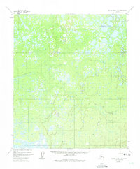
1952 Map of Kateel River A-2
USGS Topo · Published 1957About this map
The Natlaratlen River winds through this interior Alaskan wilderness, recorded here as it appeared in the early 1950s. This survey, compiled from 1952 aerial photography and 1956 multiplex topographic methods, depicts a vast landscape defined by intricate wetland systems and hundreds of unnamed lakes and ponds. The lack of roads or trails in this area at the time of publication underscores its isolation within the Alaska-Fourth Judicial Division. The contour lines reveal a complex drainage basin where the river system carves through a mosaic of muskeg and low-lying hills, illustrating the natural hydrological patterns of the Yukon-Koyukuk region before any modern industrial footprint or significant infrastructure reached this portion of the interior.
Find a feature on this map
1 named feature on this map. Tap any name to fly to it.
Don’t see what you’re looking for? This feature index may not catch every label — zoom into the map to look around manually.
Map Details
Editions of this 1952 Kateel River A-2 Map
2 editions found
Other maps of this area

1945 · Nulato
USGS Topo · 1:250,000

1951 · Nulato
USGS Topo · 1:250,000

1951 · Kateel River
USGS Topo · 1:250,000

1952 · Nulato D-1
USGS Topo · 1:63,360

1952 · Nulato D-3
USGS Topo · 1:63,360

1952 · Kateel River A-1
USGS Topo · 1:63,360

1952 · Nulato D-2
USGS Topo · 1:63,360

1952 · Kateel River A-3
USGS Topo · 1:63,360

1952 · Kateel River B-1
USGS Topo · 1:63,360

1952 · Kateel River B-3
USGS Topo · 1:63,360