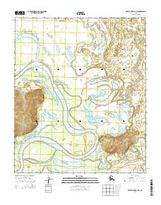
2015 Map of Kateel River A-3 SW
USGS Topo · Published 2015About this map
The Koyukuk River dominates this interior landscape, winding in large, elegant loops across the floodplain of the Yukon-Koyukuk region. In this 2015 perspective, the river's dynamic nature is evident through the complex network of side channels and wetlands it supports, including the winding Nikolai Slough in the southeast. The terrain transition is sharp where the water meets the rising elevation of local hills, particularly near the western river bends where the contour lines tighten significantly. This topographic study captures a moment of natural flux in a remote Alaskan river system, illustrating how the water has carved through the township sections of T4S, T5S, and T6S over time. It is a portrait of a landscape defined by seasonal flow and the constant reshaping of its banks.
Find a feature on this map
8 named features on this map. Tap any name to fly to it.
Don’t see what you’re looking for? This feature index may not catch every label — zoom into the map to look around manually.
Map Details
Editions of this 2015 Kateel River A-3 SW Map
This is the sole edition of this map. No revisions or reprints were ever made.
Other maps of this area

1945 · Nulato
USGS Topo · 1:250,000

1951 · Nulato
USGS Topo · 1:250,000

1951 · Kateel River
USGS Topo · 1:250,000

1952 · Nulato D-3
USGS Topo · 1:63,360

1952 · Kateel River A-4
USGS Topo · 1:63,360

1952 · Nulato D-4
USGS Topo · 1:63,360

1952 · Kateel River A-3
USGS Topo · 1:63,360

1952 · Nulato
USGS Topo · 1:250,000
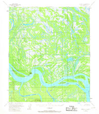
1954 · Nulato D-3
USGS Topo · 1:63,360

1955 · Kateel River
USGS Topo · 1:250,000