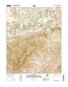
2016 Map of Kateel River B-1 NE
USGS Topo · Published 2016About this map
Dulbi Slough meanders across the northern half of this terrain, its winding course defining a landscape of complex oxbows and marshy lowlands within the Yukon-Koyukuk region. In the south, the topography shifts abruptly toward rising uplands, where the drainage patterns give way to defined ridges. This 2016 survey documents the intricate hydraulic network of the Interior, where the slough functions as a primary geographic marker across the township boundaries of T1n R13e and T1n R14e. The transition from the saturated basin of the slough to the higher ground in T1s R13e and T1s R14e illustrates the stark geomorphology of the Alaskan wilderness, preserved here through high-resolution modern elevation data.
Find a feature on this map
5 named features on this map. Tap any name to fly to it.
Don’t see what you’re looking for? This feature index may not catch every label — zoom into the map to look around manually.
Map Details
Editions of this 2016 Kateel River B-1 NE Map
This is the sole edition of this map. No revisions or reprints were ever made.
Other maps of this area

1951 · Kateel River
USGS Topo · 1:250,000

1951 · Melozitna
USGS Topo · 1:250,000

1952 · Kateel River B-1
USGS Topo · 1:63,360

1954 · Melozitna C-6
USGS Topo · 1:63,360

1954 · Kateel River C-1
USGS Topo · 1:63,360
1954 · Melozitna B-6
USGS Topo · 1:63,360

1955 · Kateel River
USGS Topo · 1:250,000

1956 · Melozitna
USGS Topo · 1:250,000
2016 · Kateel River C-1 SE
USGS Topo · 1:25,000
2016 · Kateel River B-1 SW
USGS Topo · 1:25,000