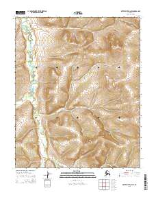
2015 Map of Kateel River C-6 SW
USGS Topo · Published 2015About this map
Tagagawik River winds through the northwestern corner of this territory, carving a distinct hydrological path through a landscape defined by sharp elevation shifts. This 2015 survey, published by the U.S. Geological Survey, illustrates a remote portion of the Alaskan interior where the terrain rises from the river valley into several significant topographical summits. The map serves as a precise record of the Public Land Survey System grid, detailing sections across townships including t3n r2w, t2n r1w, and t1n r1e. This intersection of coordinate systems and natural watercourses provides a clear look at how the Alaskan backcountry was partitioned for administrative and geological study in the early twenty-first century.
Find a feature on this map
10 named features on this map. Tap any name to fly to it.
Don’t see what you’re looking for? This feature index may not catch every label — zoom into the map to look around manually.
Map Details
Editions of this 2015 Kateel River C-6 SW Map
This is the sole edition of this map. No revisions or reprints were ever made.
Other maps of this area

1951 · Candle
USGS Topo · 1:250,000

1951 · Kateel River
USGS Topo · 1:250,000

1954 · Candle C-1
USGS Topo · 1:63,360

1954 · Candle B-1
USGS Topo · 1:63,360

1954 · Kateel River C-6
USGS Topo · 1:63,360
1955 · Kateel River B-6
USGS Topo · 1:63,360

1955 · Kateel River
USGS Topo · 1:250,000

1955 · Candle
USGS Topo · 1:250,000

1964 · Candle
USGS Topo · 1:250,000
2015 · Candle C-1 NE
USGS Topo · 1:25,000