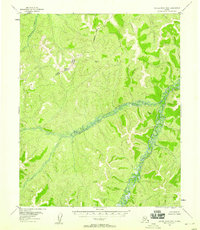
1955 Map of Kateel River B-6
USGS Topo · Published 1958About this map
The Tagagawik River snakes through the northwest corner of this sub-Arctic landscape, while the wider Box River dominates the central and eastern portions of the quadrangle. This 1955 survey illustrates a wilderness defined by its drainage patterns, with the river beds featuring intricate braiding and marshy banks that suggest a low-gradient, high-sediment environment. Beyond the water, the map documents the Second Judicial Division and Fourth Judicial Division boundary as it cuts across the high ground between the drainage basins. No roads, trails, or permanent settlements are recorded on this sheet, emphasizing the area's isolation during the mid-century period. The topography was established using aerial photography from 1952 and 1955, providing a precise record of the winding watercourses and the approximate boundary lines that divided the administrative territories of the Alaska interior.
Find a feature on this map
4 named features on this map. Tap any name to fly to it.
Don’t see what you’re looking for? This feature index may not catch every label — zoom into the map to look around manually.
Map Details
Editions of this 1955 Kateel River B-6 Map
2 editions found
Other maps of this area

1951 · Candle
USGS Topo · 1:250,000

1951 · Kateel River
USGS Topo · 1:250,000
1952 · Kateel River A-5
USGS Topo · 1:63,360

1954 · Candle A-1
USGS Topo · 1:63,360

1954 · Kateel River B-5
USGS Topo · 1:63,360

1954 · Candle C-1
USGS Topo · 1:63,360

1954 · Candle B-1
USGS Topo · 1:63,360

1954 · Kateel River C-6
USGS Topo · 1:63,360
1954 · Kateel River A-5
USGS Topo · 1:63,360

1955 · Kateel River B-5
USGS Topo · 1:63,360