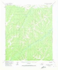
1954 Map of Kateel River A-5
USGS Topo · Published 1974About this map
Gisasa River and its winding tributaries dominate this mid-century survey of the Alaskan interior. Compiled from 1952 aerial photography and 1954 field annotations, the landscape reflects a vast, roadless wilderness typical of the Yukon-Koyukuk region before modern development. Notable survey markers like VABM 2452 Nix and VABM 1919 Rain provide specific geographic anchors within the drainage basin of the Honhosa River. The absence of established settlements, trails, or man-made structures on this sheet underscores the isolation of this territory during the territorial era, just years before Alaska achieved statehood. The map serves as a primary record of the natural hydrology and topographical contours of the Kateel River basin in its nearly pristine mid-century state.
Find a feature on this map
4 named features on this map. Tap any name to fly to it.
Don’t see what you’re looking for? This feature index may not catch every label — zoom into the map to look around manually.
Map Details
Editions of this 1954 Kateel River A-5 Map
2 editions found
Other maps of this area

1945 · Nulato
USGS Topo · 1:250,000

1951 · Nulato
USGS Topo · 1:250,000

1951 · Kateel River
USGS Topo · 1:250,000

1952 · Nulato D-5
USGS Topo · 1:63,360

1952 · Kateel River A-4
USGS Topo · 1:63,360

1952 · Nulato D-4
USGS Topo · 1:63,360

1952 · Nulato
USGS Topo · 1:250,000

1952 · Kateel River B-4
USGS Topo · 1:63,360
1952 · Kateel River A-5
USGS Topo · 1:63,360

1954 · Kateel River B-5
USGS Topo · 1:63,360