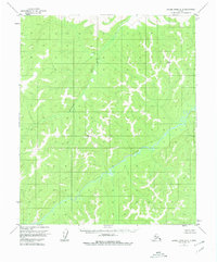
1954 Map of Kateel River A-5
USGS Topo · Published 1980About this map
Gisasa River and its winding tributaries define this interior Alaska landscape, captured in a survey based on early 1950s aerial photography. The terrain is characterized by complex drainage patterns and numerous high points, including the geodetic markers VABM 1919 Rain and VABM 2152 Nod. Flowing from the north, the Honhosa River contributes to the intricate network of watercourses that shaped the movement of people and wildlife through this unpopulated wilderness. This edition reflects the land as it was understood in the mid-20th century, before major modern infrastructure, showing an expanse of unsurveyed and unmarked locations that remained largely wild. The map provides an essential baseline for researchers tracking changes in the river morphology and the shifting boundaries of the riparian swamps.
Find a feature on this map
4 named features on this map. Tap any name to fly to it.
Don’t see what you’re looking for? This feature index may not catch every label — zoom into the map to look around manually.
Map Details
Editions of this 1954 Kateel River A-5 Map
2 editions found
Other maps of this area

1945 · Nulato
USGS Topo · 1:250,000

1951 · Nulato
USGS Topo · 1:250,000

1951 · Kateel River
USGS Topo · 1:250,000

1952 · Nulato D-5
USGS Topo · 1:63,360

1952 · Kateel River A-4
USGS Topo · 1:63,360

1952 · Nulato D-4
USGS Topo · 1:63,360

1952 · Nulato
USGS Topo · 1:250,000

1952 · Kateel River B-4
USGS Topo · 1:63,360
1952 · Kateel River A-5
USGS Topo · 1:63,360

1954 · Kateel River B-5
USGS Topo · 1:63,360