
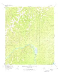
1952 Map of Nulato D-5
USGS Topo · Published 1957About this map
Nulato River and Gisasa River dominate this interior Alaskan landscape as it was documented in the early 1950s. The terrain is marked by high-altitude survey points like VABM 2462 Blind and VABM 2233 First, which stand as significant landmarks for the 1956 topographic mapping process. A remote Cabin and an Aband Telegraph Line provide rare evidence of human activity and communication infrastructure in this wilderness area. The drainage network is further defined by tributaries such as Woodyard Creek and Mukluk Creek, which carve through the dense contour lines of the Fourth Judicial Division. This sheet captures a transition point in frontier cartography, where aerial photography began to precisely reveal the complex waterway and ridge systems of the Yukon-Koyukuk region.
Find a feature on this map
9 named features on this map. Tap any name to fly to it.
Don’t see what you’re looking for? This feature index may not catch every label — zoom into the map to look around manually.
Map Details
Editions of this 1952 Nulato D-5 Map
2 editions found
Other maps of this area

1945 · Nulato
USGS Topo · 1:250,000

1951 · Nulato
USGS Topo · 1:250,000

1951 · Kateel River
USGS Topo · 1:250,000

1952 · Nulato C-4
USGS Topo · 1:63,360

1952 · Kateel River A-4
USGS Topo · 1:63,360

1952 · Nulato D-4
USGS Topo · 1:63,360

1952 · Nulato C-6
USGS Topo · 1:63,360

1952 · Nulato C-5
USGS Topo · 1:63,360

1952 · Nulato
USGS Topo · 1:250,000
1952 · Kateel River A-5
USGS Topo · 1:63,360