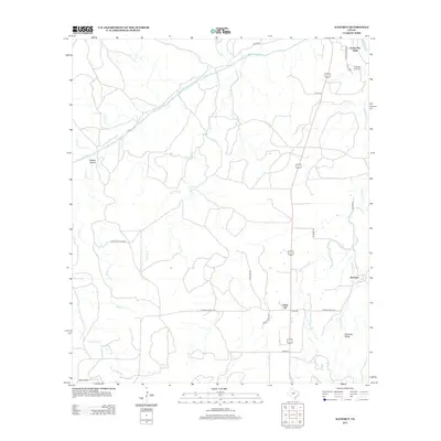
2012 Map of Katemcy
USGS Topo · Published 2012About this map
The San Saba River winds through this central Texas landscape, which is defined by small rural settlements and a network of ranch roads. The tiny community of Katemcy and the prominent Katemcy Rocks serve as landmarks in the eastern portion of the quadrangle. To the north, the historic burial ground at Camp San Saba Cem sits near the namesake settlement of Camp San Saba, which historically served as a frontier military site and later a crossroads. The terrain is deeply carved by drainage systems like Decker Hollow and numerous tributaries, including Schmidt Br and Cavin Br. This survey illustrates the persistent agricultural and ranching footprint of Mason County, where roads such as W Ranch Road 1222 and State Hwy Ranch Rd provide the primary infrastructure through the rolling brushland.
Find a feature on this map
28 named features on this map. Tap any name to fly to it.
Don’t see what you’re looking for? This feature index may not catch every label — zoom into the map to look around manually.
Map Details
Editions of this 2012 Katemcy Map
This is the sole edition of this map. No revisions or reprints were ever made.
Other maps of this area

1887 · Mason
USGS Topo · 1:125,000

1894 · Brady
USGS Topo · 1:125,000

1894 · Mason
USGS Topo · 1:125,000

1954 · Brownwood
USGS Topo · 1:250,000

1954 · Llano
USGS Topo · 1:250,000

1955 · Llano
USGS Topo · 1:250,000

1956 · Llano
USGS Topo · 1:250,000

1962 · Purdy Hill
USGS Topo · 1:24,000

1963 · Spy Rock
USGS Topo · 1:24,000
1963 · Voca
USGS Topo · 1:24,000