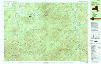
1979 Map of Keene Valley
USGS Topo · Published 1979About this map
Mt Van Hoevenberg Recreational Center stands as a primary landmark in this late-1970s survey, featuring the Bobsled Run, Biathlon Stadium, and Cross Country Stadium. This area within the Adirondack Park showcases a landscape defined by dramatic elevation, from the heights of Algonquin Peak and Wright Peak to the narrow valleys of the Ausable River.
Find a feature on this map
111 named features on this map. Tap any name to fly to it.
Don’t see what you’re looking for? This feature index may not catch every label — zoom into the map to look around manually.
Map Details
Editions of this 1979 Keene Valley Map
2 editions found
Other maps of this area

1894 · Elizabethtown
USGS Topo · 1:62,500

1895 · Elizabethtown
USGS Topo · 1:62,500

1895 · Mt. Marcy
USGS Topo · 1:62,500

1895 · Ausable
USGS Topo · 1:62,500

1896 · Lake Placid
USGS Topo · 1:62,500

1898 · Lake Placid
USGS Topo · 1:62,500

1901 · Elizabethtown
USGS Topo · 1:62,500

1902 · Mt. Marcy
USGS Topo · 1:62,500

1902 · Saranac
USGS Topo · 1:62,500

1903 · Ausable
USGS Topo · 1:62,500