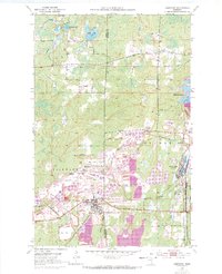
1952 Map of Keewatin
USGS Topo · Published 1971About this map
The iron mining operations of the Mesabi Range dominate this mid-century landscape on the Itasca Co St Louis Co line. Massive excavations and extensive Mine Dumps surround the village of Keewatin, which sits at the heart of a dense industrial network. Major operations such as the Mesabi Chief Mine, Mississippi No 1 Mine, and St Paul Mine define the southern terrain, while the northern sections of the map show the transition from undisturbed lakes like Libby Lake and Horsehead Lake into the heavy industrial footprint of the Stevenson Mine. The Burlington Northern railroad serves as the primary artery connecting these pits to the settlement at Kelly Lake. These 1969 revisions, noted in purple, document the expansion of tailings ponds and the shifting borders of open pits like the Mahoning Mine during a period of peak extraction.
Find a feature on this map
40 named features on this map. Tap any name to fly to it.
Don’t see what you’re looking for? This feature index may not catch every label — zoom into the map to look around manually.
Map Details
Editions of this 1952 Keewatin Map
4 editions found
Other maps of this area

1951 · Hibbing
USGS Topo · 1:24,000

1952 · Keewatin
USGS Topo · 1:24,000

1952 · Riley
USGS Topo · 1:24,000

1952 · Nashwauk
USGS Topo · 1:24,000

1952 · Silica
USGS Topo · 1:24,000

1952 · Pengilly
USGS Topo · 1:24,000

1954 · Hibbing
USGS Topo · 1:250,000

1955 · Dewey Lake
USGS Topo · 1:24,000

1957 · Hibbing
USGS Topo · 1:250,000

1957 · Hibbing
USGS Topo · 1:24,000