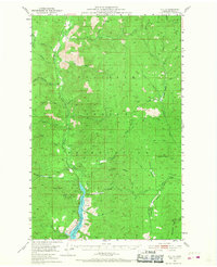
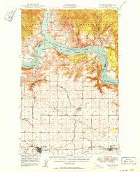
1952 Map of Keller
USGS Topo · Published 1968About this map
Colville Indian Reservation lands dominate this mid-century topographic record, centered on the settlement of Keller along the Sanpoil River. The landscape is defined by the significant rise of Mount Tolman and Solome Mountain, while the southern reaches of the quadrangle show the impact of the Columbia River's impoundment with the presence of Franklin D Roosevelt Lake. This era of the reservation shows a distinct mineral-extraction footprint, including the Keno Mine, Shamrock Mine, and Pacific Mutual Mines. The mapping also documents a remote network of drainages such as Capoose Creek and Manila Creek, and the lower reaches of Watson Ridge. A Gaging Sta along the river and various gravel pits indicate the ongoing management of local resources and infrastructure following the creation of the Coulee Dam National Recreational Area.
Find a feature on this map
40 named features on this map. Tap any name to fly to it.
Don’t see what you’re looking for? This feature index may not catch every label — zoom into the map to look around manually.
Map Details
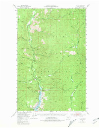
Editions of this 1952 Keller Map
3 editions found
Other maps of this area

1948 · Grand Coulee Dam
USGS Topo · 1:62,500
1948 · Wilbur
USGS Topo · 1:62,500

1948 · Wilmont Creek
USGS Topo · 1:62,500
1948 · Lincoln
USGS Topo · 1:62,500

1950 · Lincoln
USGS Topo · 1:62,500

1950 · Wilmont Creek
USGS Topo · 1:62,500
1950 · Wilbur
USGS Topo · 1:62,500

1950 · Grand Coulee Dam
USGS Topo · 1:62,500

1950 · Nespelem
USGS Topo · 1:62,500
1952 · Keller
USGS Topo · 1:62,500