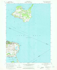
1969 Map of Kelleys Island
USGS Topo · Published 1971About this map
Kelleys Island and the Danbury peninsula define this maritime landscape in Lake Erie, where 1960s industrial and recreational land use coexist. On the island, extensive quarries dominate the northern and central interior, while the shoreline maintains its focus on heritage and tourism at sites like the Glacial Grooves State Memorial and Inscription Rock. Across the South Passage, the community of Marblehead is anchored by the Marblehead Lighthouse and a massive limestone quarrying operation, complete with a specialized conveyor system and tailings piles. Genealogical interest is high on the Danbury side, where the Russian Cem and Woolcott Cem are located, as well as on Johnson Island, which is noted for its Confederate Cem. This period shows the transition from a traditional quarry-and-fishing economy toward a resort-driven future at places like Camp Patmos and Bay Point Marina.
Find a feature on this map
63 named features on this map. Tap any name to fly to it.
Don’t see what you’re looking for? This feature index may not catch every label — zoom into the map to look around manually.
Map Details
Editions of this 1969 Kelleys Island Map
2 editions found
Other maps of this area

1901 · Put-In-Bay
USGS Topo · 1:62,500

1901 · Bellevue
USGS Topo · 1:62,500

1903 · Bellevue
USGS Topo · 1:62,500

1903 · Put In Bay
USGS Topo · 1:62,500

1904 · Sandusky
USGS Topo · 1:62,500

1916 · Kelleys Island
USGS Topo · 1:62,500

1919 · Kelleys Island
USGS Topo · 1:62,500

1956 · Toledo
USGS Topo · 1:250,000

1959 · Sandusky
USGS Topo · 1:24,000
1959 · Huron
USGS Topo · 1:24,000