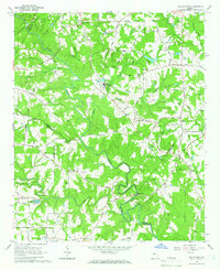
1964 Map of Kelleytown
USGS Topo · Published 1966About this map
The South River and its meandering tributaries, including Honey Creek, carve through the rolling landscape of the Georgia Piedmont, marking the boundaries between Rockdale, Henry, and Newton counties. In the mid-1960s, this area remained largely rural, anchored by small settlements like Kelleytown and Magnet. A significant spiritual landmark, the Monastery of the Holy Ghost, occupies a prominent position near the center of the sheet, reflecting the unique cultural character of the region.
Find a feature on this map
68 named features on this map. Tap any name to fly to it.
Don’t see what you’re looking for? This feature index may not catch every label — zoom into the map to look around manually.
Map Details
Editions of this 1964 Kelleytown Map
Other maps of this area

1888 · Atlanta
USGS Topo · 1:125,000

1890 · Atlanta
USGS Topo · 1:125,000

1892 · Atlanta
USGS Topo · 1:125,000

1895 · Atlanta
USGS Topo · 1:125,000

1896 · Monroe
USGS Topo · 1:125,000

1953 · Atlanta
USGS Topo · 1:250,000

1953 · Athens
USGS Topo · 1:250,000

1956 · Conyers
USGS Topo · 1:24,000

1956 · Redan
USGS Topo · 1:24,000

1957 · Atlanta
USGS Topo · 1:250,000