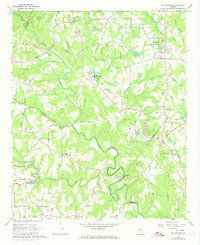
1964 Map of Kelleytown
USGS Topo · Published 1974About this map
The South River meanders across this rural landscape, forming the natural border between Rockdale, Henry, and Newton counties. In the early 1960s, this area remained largely pastoral, characterized by family farms and significant religious landmarks such as the Monastery of the Holy Ghost and the historic Kelley Chapel near Kelleytown. The presence of numerous family burial grounds, including the Gleaton Cem, Albert Cem, and Bonner Cem, suggests a deeply rooted community structure with generations of local history tied to specific land tracts.
Find a feature on this map
79 named features on this map. Tap any name to fly to it.
Don’t see what you’re looking for? This feature index may not catch every label — zoom into the map to look around manually.
Map Details
Editions of this 1964 Kelleytown Map
Other maps of this area

1888 · Atlanta
USGS Topo · 1:125,000

1890 · Atlanta
USGS Topo · 1:125,000

1892 · Atlanta
USGS Topo · 1:125,000

1895 · Atlanta
USGS Topo · 1:125,000

1896 · Monroe
USGS Topo · 1:125,000

1953 · Atlanta
USGS Topo · 1:250,000

1953 · Athens
USGS Topo · 1:250,000

1956 · Conyers
USGS Topo · 1:24,000

1956 · Redan
USGS Topo · 1:24,000

1957 · Atlanta
USGS Topo · 1:250,000