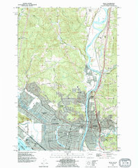
1990 Map of Kelso
USGS Topo · Published 1995About this map
Longview and Kelso sit at the strategic confluence of three major waterways, where the Cowlitz River and Coweman River meet the massive flow of the Columbia River. The urban landscape is defined by the unique crescent of Lake Sacajawea, a centerpiece for the planned neighborhoods of Columbia Valley Gardens and Columbia Heights. Industrial and transit infrastructure is prominent, with the Burlington Northern railroad and the Pacific Highway serving as primary north-south corridors through West Kelso and Lexington. Beyond the dense city blocks, the terrain rises sharply toward Beacon Hill and Mount Solo, while the riverfront is fortified with a continuous Levee system. This 1990 revision shows the mature development of Lower Columbia College and the surrounding residential districts like Davis Terrace and Pleasant Hill.
Find a feature on this map
55 named features on this map. Tap any name to fly to it.
Don’t see what you’re looking for? This feature index may not catch every label — zoom into the map to look around manually.
Map Details
Editions of this 1990 Kelso Map
This is the sole edition of this map. No revisions or reprints were ever made.
Other maps of this area

1919 · Mayger
USGS Topo · 1:62,500

1921 · Kalama
USGS Topo · 1:62,500

1941 · Olequa
USGS Topo · 1:62,500

1941 · Clatskanie
USGS Topo · 1:62,500

1952 · Clatskanie
USGS Topo · 1:62,500

1953 · Hoquiam
USGS Topo · 1:250,000

1953 · Castle Rock
USGS Topo · 1:62,500

1953 · Mt. Brynion
USGS Topo · 1:24,000

1953 · Ryderwood
USGS Topo · 1:62,500

1953 · Rainier
USGS Topo · 1:24,000