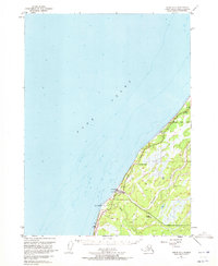
1951 Map of Kenai A-5
USGS Topo · Published 1972About this map
Ninilchik sits along the western shoreline of the Kenai Peninsula in the early 1950s, serving as a primary point of settlement where the Ninilchik River and Deep Creek meet the waters of Cook Inlet. This survey, compiled from aerial photography taken in 1950, documents the early alignment of the Sterling Highway as it skirts the coast. The landscape is characterized by its transition from the tidal flats near Cape Ninilchik to the interior marshlands and low-lying hills.
Find a feature on this map
16 named features on this map. Tap any name to fly to it.
Don’t see what you’re looking for? This feature index may not catch every label — zoom into the map to look around manually.
Map Details
Editions of this 1951 Kenai A-5 Map
3 editions found
Other maps of this area

1944 · Kenai
USGS Topo · 1:250,000

1946 · Seldovia D-5
USGS Topo · 1:63,360

1949 · Seldovia D-4
USGS Topo · 1:63,360

1950 · Kenai
USGS Topo · 1:250,000

1951 · Seldovia D-5
USGS Topo · 1:63,360

1951 · Seldovia D-4
USGS Topo · 1:63,360

1951 · Seldovia
USGS Topo · 1:250,000

1951 · Kenai A-5
USGS Topo · 1:63,360

1951 · Kenai B-4
USGS Topo · 1:63,360

1951 · Kenai A-4
USGS Topo · 1:63,360