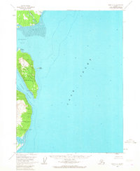
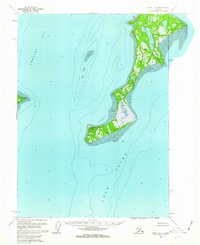
1958 Map of Kenai A-7
USGS Topo · Published 1968About this map
Tuxedni National Wildlife Refuge dominates the coastline of Chisik Island in this mid-century survey of the western shores of Cook Inlet. The map highlights a landscape defined by dramatic tidal shifts and maritime activity, with extensive Tidal Flats bordering the mouth of the Crescent River. On the eastern side of the island, Snug Harbor serves as a sheltered anchorage, supported by a localized Cannery operation that points to the region's historical fishing industry. The topography reveals a transition from these muddy flats and coastal waters to the elevated points of Iliamna Pt and the small outcropping of Duck Island. Away from the industrial site at the harbor, a solitary Cabin represents the sparse human footprint in this corner of the Tuxedni Bay region during the late 1950s.
Find a feature on this map
14 named features on this map. Tap any name to fly to it.
Don’t see what you’re looking for? This feature index may not catch every label — zoom into the map to look around manually.
Map Details
Editions of this 1958 Kenai A-7 Map
2 editions found
Other maps of this area

1944 · Kenai
USGS Topo · 1:250,000

1950 · Kenai
USGS Topo · 1:250,000

1951 · Seldovia
USGS Topo · 1:250,000
1958 · Seldovia D-8
USGS Topo · 1:63,360
1958 · Kenai A-8
USGS Topo · 1:63,360
1958 · Kenai A-7
USGS Topo · 1:63,360

1958 · Kenai B-7
USGS Topo · 1:63,360

1958 · Kenai B-8
USGS Topo · 1:63,360
1958 · Kenai B-6
USGS Topo · 1:63,360

1958 · Kenai
USGS Topo · 1:250,000