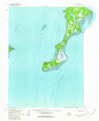
1958 Map of Kenai B-6
USGS Topo · Published 1963About this map
Kalgin Island dominates the central waters of Cook Inlet in this mid-century hydrographic and topographic study. The landscape is defined by its isolation, characterized by extensive Tidal Flats and marshy interiors drained by Swamp Creek and Packers Creek. To the west, the mainland coastline at Harriet Pt looks across Redoubt Bay toward the island's sheltered anchorages at Oldmans Bay and Cobbs Cove.
Find a feature on this map
12 named features on this map. Tap any name to fly to it.
Don’t see what you’re looking for? This feature index may not catch every label — zoom into the map to look around manually.
Map Details
Editions of this 1958 Kenai B-6 Map
2 editions found
Other maps of this area

1944 · Kenai
USGS Topo · 1:250,000

1950 · Kenai
USGS Topo · 1:250,000

1951 · Kenai A-5
USGS Topo · 1:63,360

1952 · Kenai A-5
USGS Topo · 1:63,360
1958 · Kenai A-7
USGS Topo · 1:63,360

1958 · Kenai B-7
USGS Topo · 1:63,360

1958 · Kenai C-5
USGS Topo · 1:63,360

1958 · Kenai C-6
USGS Topo · 1:63,360

1958 · Kenai C-7
USGS Topo · 1:63,360

1958 · Kenai
USGS Topo · 1:250,000