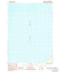
1986 Map of Kenai B-4 NW
USGS Topo · Published 1986About this map
Cook Inlet dominates this coastal survey, where the deep waters of the inlet meet the shifting shoreline of the Kenai Peninsula. The map focuses primarily on the maritime environment, documenting the vast areas of Mud that define the intertidal zone along the southeastern coast. A lone navigational Light stands as a vital landmark for vessels navigating these northern waters, situated near the transition from open water to the treacherous coastal flats. Based on field checks from 1980, the sheet provides a precise snapshot of the shoreline and maritime aids before the continued environmental shifts of the late 20th century. While the majority of the quadrangle is occupied by the water of the inlet, the charted details of the mudflats and the single light station offer essential information for historical maritime research and coastal study in this part of Alaska.
Find a feature on this map
3 named features on this map. Tap any name to fly to it.
Don’t see what you’re looking for? This feature index may not catch every label — zoom into the map to look around manually.
Map Details
Editions of this 1986 Kenai B-4 NW Map
This is the sole edition of this map. No revisions or reprints were ever made.
Other maps of this area

1944 · Kenai
USGS Topo · 1:250,000

1950 · Kenai
USGS Topo · 1:250,000

1951 · Kenai C-4
USGS Topo · 1:63,360

1951 · Kenai B-4
USGS Topo · 1:63,360

1952 · Kenai C-4
USGS Topo · 1:63,360

1952 · Kenai B-4
USGS Topo · 1:63,360

1958 · Kenai C-5
USGS Topo · 1:63,360

1958 · Kenai
USGS Topo · 1:250,000
1986 · Kenai B-4 SW
USGS Topo · 1:25,000
1986 · Kenai B-4 NE
USGS Topo · 1:25,000