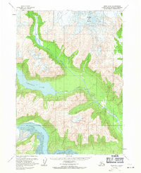
1958 Map of Kenai B-8
USGS Topo · Published 1971About this map
Redoubt Volcano dominates the northern landscape of this survey, standing as a primary landmark above the complex glacial and river systems of the western Kenai Peninsula. The drainage patterns of the North Fork and Crescent River illustrate a dynamic mountain environment where water moves from high alpine elevations down toward the coast. The central portion of the map is occupied by Crescent Lake, a significant inland water body fed by mountain runoff. Further south, the Tuxedni River terminates at a broad Tidal Flat, indicating the transition to a coastal maritime environment. This document reflects the mid-century mapping of unsurveyed and unmarked land lines, pre-determined by the Bureau of Land Management for the Seward Meridian.
Find a feature on this map
7 named features on this map. Tap any name to fly to it.
Don’t see what you’re looking for? This feature index may not catch every label — zoom into the map to look around manually.
Map Details
Editions of this 1958 Kenai B-8 Map
2 editions found
Other maps of this area

1944 · Kenai
USGS Topo · 1:250,000

1946 · Lake Clark
USGS Topo · 1:250,000

1950 · Kenai
USGS Topo · 1:250,000

1951 · Lake Clark
USGS Topo · 1:250,000

1958 · Lake Clark A-1
USGS Topo · 1:63,360

1958 · Lake Clark B-1
USGS Topo · 1:63,360
1958 · Kenai A-8
USGS Topo · 1:63,360
1958 · Kenai A-7
USGS Topo · 1:63,360

1958 · Kenai B-7
USGS Topo · 1:63,360

1958 · Kenai B-8
USGS Topo · 1:63,360