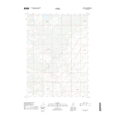
2017 Map of Kenai C-1 NW
USGS Topo · Published 2017About this map
Mystery Creek Road provides the primary corridor through this portion of the Kenai Peninsula, a landscape defined by an extensive network of wetlands and subarctic water bodies. The terrain is dominated by the northern reaches of the Moose River and the meandering course of the Chickaloon River, which shape the drainage patterns for numerous small lakes. Named features like Rabbit Foot Lake, Jay Lake, and Muskrat Lake highlight a complex hydrographic system where dry ground is scarce. In the southeast, Mystery Cr flows toward the river systems, illustrating the remote and undeveloped nature of the interior peninsula during the early twenty-first century. This survey by the U.S. Geological Survey captures a region largely devoid of permanent settlements, focused instead on the natural transition between marshland and elevated creek beds.
Find a feature on this map
15 named features on this map. Tap any name to fly to it.
Don’t see what you’re looking for? This feature index may not catch every label — zoom into the map to look around manually.
Map Details
Editions of this 2017 Kenai C-1 NW Map
This is the sole edition of this map. No revisions or reprints were ever made.
Other maps of this area

1944 · Kenai
USGS Topo · 1:250,000

1950 · Kenai
USGS Topo · 1:250,000

1951 · Kenai C-1
USGS Topo · 1:63,360

1951 · Kenai C-2
USGS Topo · 1:63,360

1951 · Kenai D-1
USGS Topo · 1:63,360

1951 · Kenai D-2
USGS Topo · 1:63,360

1952 · Kenai D-2
USGS Topo · 1:63,360

1952 · Kenai C-1
USGS Topo · 1:63,360

1952 · Kenai C-2
USGS Topo · 1:63,360
1952 · Kenai D-1
USGS Topo · 1:63,360