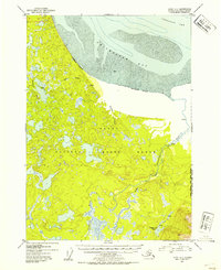
1952 Map of Kenai D-1
USGS Topo · Published 1954About this map
Kenai National Moose Range dominates this landscape on the southern shores of Turnagain Arm, revealing a complex network of wetlands and glacial drainage before mid-century development. The area is defined by the massive tidal flats of Chickaloon Bay, where extensive areas of Mud are exposed at low tide. This 1952 topographic study, compiled from earlier aerial photography and hydrographic charts, shows the primitive infrastructure of the era, marked by isolated cabins and a few backcountry routes such as a Ski Mobile path and a Trail. Notable inland water features include the meandering Chickaloon River, Bedlam Creek, and Pincher Creek, which drain toward the bay. Near the southeastern boundary with the Chugach National Forest, Trapper Joe Lake serves as a distinct landmark for those tracking early twentieth-century land use and habitation in this part of the Kenai Peninsula.
Find a feature on this map
15 named features on this map. Tap any name to fly to it.
Don’t see what you’re looking for? This feature index may not catch every label — zoom into the map to look around manually.
Map Details
Editions of this 1952 Kenai D-1 Map
2 editions found
Other maps of this area

1944 · Kenai
USGS Topo · 1:250,000

1949 · Tyonek
USGS Topo · 1:250,000

1950 · Kenai
USGS Topo · 1:250,000

1951 · Seward
USGS Topo · 1:250,000

1951 · Anchorage
USGS Topo · 1:250,000

1951 · Tyonek
USGS Topo · 1:250,000

1951 · Kenai C-1
USGS Topo · 1:63,360

1951 · Kenai C-2
USGS Topo · 1:63,360

1951 · Kenai D-1
USGS Topo · 1:63,360

1951 · Kenai D-2
USGS Topo · 1:63,360