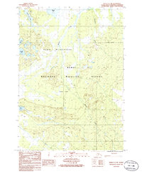
1986 Map of Kenai C-1 NW
USGS Topo · Published 1986About this map
The Kenai National Wildlife Refuge dominates this mid-1980s topographic record, illustrating a landscape defined by federal land conservation following the Alaska National Interest Lands Conservation Act. The map captures the remote character of the Kenai Wilderness, where the Chickaloon River and Mystery Creek drain a complex network of wetlands and small lakes. Notable water bodies such as Moose Lake, Muskrat Lake, and Rabbit Foot Lake are scattered across the terrain, interspersed with an intricate system of unnamed ponds and marshes. While much of the area is preserved for its natural state, the presence of a Pipeline and a few unimproved trails in the southern portion indicates the thin intersections between resource infrastructure and protected wilderness. This provisional survey provides a precise look at the hydrology and terrain elevations of the peninsula before more modern developments or shifts in the shoreline occurred.
Find a feature on this map
11 named features on this map. Tap any name to fly to it.
Don’t see what you’re looking for? This feature index may not catch every label — zoom into the map to look around manually.
Map Details
Editions of this 1986 Kenai C-1 NW Map
This is the sole edition of this map. No revisions or reprints were ever made.
Other maps of this area

1944 · Kenai
USGS Topo · 1:250,000

1950 · Kenai
USGS Topo · 1:250,000

1951 · Kenai C-1
USGS Topo · 1:63,360

1951 · Kenai C-2
USGS Topo · 1:63,360

1951 · Kenai D-1
USGS Topo · 1:63,360

1951 · Kenai D-2
USGS Topo · 1:63,360

1952 · Kenai D-2
USGS Topo · 1:63,360

1952 · Kenai C-1
USGS Topo · 1:63,360

1952 · Kenai C-2
USGS Topo · 1:63,360
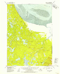
1952 · Kenai D-1
USGS Topo · 1:63,360