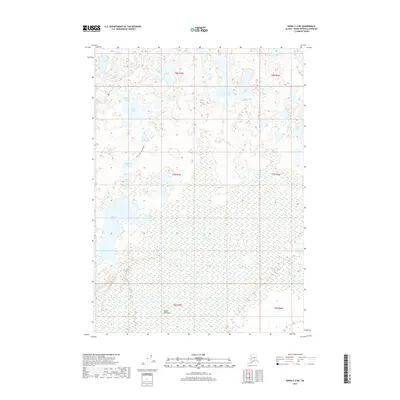
2017 Map of Kenai C-2 NE
USGS Topo · Published 2017About this map
Swan Lake and the meandering Moose River dominate this portion of the Kenai Peninsula, where a complex network of glacial kettle lakes defines the interior landscape. The 2017 survey highlights the Swan Lake Canoe Route, a critical recreational and historical artery that threads through water bodies such as Duckling Lake, Birch Lake, and Mallard Lake. This area is characterized by vast wetland expanses and interconnected waterways, reflecting the intricate hydrography of the region's wilderness. Smaller lakes with avian-inspired names, including Teal Lake, Raven Lake, and Buteo Lake, are scattered throughout the township grids, illustrating the density of the freshwater system. The presence of the Portage Lakes suggests the historical necessity of overland transport between these navigable basins before modern infrastructure reached this part of the peninsula.
Find a feature on this map
24 named features on this map. Tap any name to fly to it.
Don’t see what you’re looking for? This feature index may not catch every label — zoom into the map to look around manually.
Map Details
Editions of this 2017 Kenai C-2 NE Map
This is the sole edition of this map. No revisions or reprints were ever made.
Other maps of this area

1944 · Kenai
USGS Topo · 1:250,000

1950 · Kenai
USGS Topo · 1:250,000

1951 · Kenai C-1
USGS Topo · 1:63,360

1951 · Kenai C-2
USGS Topo · 1:63,360

1951 · Kenai D-1
USGS Topo · 1:63,360

1951 · Kenai D-2
USGS Topo · 1:63,360

1952 · Kenai D-2
USGS Topo · 1:63,360

1952 · Kenai C-1
USGS Topo · 1:63,360

1952 · Kenai C-2
USGS Topo · 1:63,360
1952 · Kenai D-1
USGS Topo · 1:63,360